– post 6 of 8 –
A RIVER OF TIME
Georgia to the Gulf, 225 river miles, 10 paddle days
.
Day 8, Riverside camp (59 rm) to Fanning Springs State Park (34.5rm)
A primitive camp/riverside night; where the only sounds were the occasional mullet jump and Sturgeon splash. – note; with just a little more effort better stops just ahead at hwy 340 bridge (park top of landing) OR Gornto Park.
In beginning a new day there was yet another spring just down the way – another corner to explore. While researching prior to this venture the advice was notably passed along NOT to paddle the river quickly; “take your time” – it’s good advice, especially for the mornings.
Between the periodic jumps of mullet, sturgeons (dinosaur fish) would do the same – yet Sturgeons can be much larger (size of a dog). These large fish clear the water completely before crashing back with a ‘thud’ like splash, there were many along the way – none predictable (picture of a mullet in mid-air at Ichetucknee Springs).
There are warning signs posted noting the potential of injury if a sturgeon happens to land in your lap, I think the danger is more with speed and being in a power boat. The likely hood of concern for a paddler is more in the lines of encountering a manatee pop-up… (suprize). I never felt concern but did catch a few glimpses, these fish can be huge (manatees are friendly).
Approaching Gornto Springs its easy to admire the individual efforts at dockage – some folks are more successful than others. The occasional ‘flush’ of water coming ‘down the pike’ has to be considered and I’m sure the dead trees/logs/debris within that gush ‘reak their own share of havoc to the structures along the way. It was in this neighborhood that I realized where all those old pontoons ‘go to pasture’…..
The docks can be improvised or have evolved in various fashion to suit the shore-scape, lots of plastic barrels and retired pontoons. There were also the ‘Florida rooms’ built in all kinds of places – on all kinds of posts and trees, a good number improperly shored or braced – ‘old-man river’ style.
There were also some solid one’s too.
While taking a stretch (trail-break) I noticed a small spring and figured that I might take a walk and take a picture or two deeper in the woods. As I crossed the dew covered ground I sensed something in the distance lurking in my direction, a white object – moving stealth-like – so I slowly (and quietly) stepped across the kayak, and quietly sat – pushing back into the water. I sat motionless watching it’s continued approach.
 This albino doberman sniffed his way to the shore and was nothing but muscle – lean, yet seemingly well mannered (damn glad). He wasn’t being aggressive towards me, but then with a single bark, I moved on.
Wild looking and I say ‘albino’ because I noticed pinkish nose and ear coloring – “no maas buddy.”
‘Paradise’ (its for sale).
A little further down was a logging operation ramp (like on the discovery channel) along with several other machines that make it all happen. I noticed only this operation along the Suwannee – from what I hear they can log whats under the water but cannot disturb what is above the waterline. Another one of those things to ponder on, could the logging disturb the natural process of the Suwannee (water quality or bottom erosion)? – I didn’t come up with an answer.
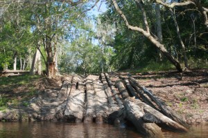
The cement of an old boat-ramp mangled by the roots of an even older oak.
 I had been thinking too about what someone had asked me a few days earlier “Whats your purpose?” they asked as I passed – “just paddling” was my response, but it left me to ponder.
I suppose that I paddle for several reasons, (one) – I like the back-roads of our country because they are less exposed and intriguing, maybe waterways are similar; primitive avenues. (two) I see new things, interesting things – ideas, I see Americana – I see character.
Paddling is also pretty basic, cost-effective, and eco-friendly – it’s a pleasant ride between here and somewhere else.
After lunch the wind came from the South in a convincing manner, the Suwannee is much wider now and its almost possible to watch the wind ‘funneling’ down and racing across the water towards you – have the hat-strap to the front. Because of how the river meanders it is also possible to work the wind much like paddling against a current, utilizing wind-eddy’s or land features for ‘dead-air’ instead of the water kind. Having a compass on the bow is interesting too, I watched it frequently for Gulf orientation.
Unrelenting wind, all day – white caps even, the spray-skirt came in handy for both the wind and the sun. As for my arms, I haven’t noticed them in several days, I know they are there moving the paddles but I’m relaxed and enjoying the scenery. Sorta like like riding a bicycle, feet are moving and you’re just sittin there just there ‘lookin around – such has been my paddlin lately. Paddle on.
Railroad trestle above Fanning Springs
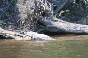
Gator buddy, I didn’t see alot of gators maybe five or six all together – not sure why, April is early in the year – they court in May.
There were several sections of the river where it was possible to hear traffic looong before you saw it or the bridge carrying it. This area before Fanning Springs and Hwy 98 was one of those areas (I-75 from White Springs was the other).
A forgotten landing above Fanning Springs (cut-off by a new highway I think).
It had been a tough paddle against the wind all day, 21-miles I think, and it was after 4 pm. Just after Hwy-98 bridge was Fanning Springs State Park a welcome sight, and with a weather front coming through I wasn’t going any further tonight.
 As I approached the State Park ramp this group of Outward-Bound folks were just setting out, evidently they paddle, camp, exercise, and discuss getting their lives back on track before setting out for the day. I have run across these kids several times before on the Suwannee (once at Cone Bridge). You can’t help but to admire the young leaders for doing such a thing in/with this environment. It all leaves me to appreciate the Suwannee a little more for being the quality environment that it is.
Fanning Springs State Park emphasis is more on the Springs to which the community (‘cut-offs and dated bathing suits’) frequent rather than camping – so there are no established campsites with power or water service. There is a cold-water outside shower or there are the springs, no hot water shower to defunk, I used the springs.
The camp sites are in a field with a large fire-ring and near an out door stage. The highway and eating establishments (land-food) are just across the street, its a deal for 5-bucks a night (and its level). They do have cabins, for those that have the ability to plan ahead (2-night minimum, $100 a night).
I had a great day of paddling, even with the head-wind.
Barely making it back after a fine oyster dinner I squared things away for any impending storm which might arrive during the night (it came at 6 am it was gone in an hour and a half). zzzzzzz
.
Facebook Post; “Mon – day 8; 22 hard miles against a stiff wind, camped Fanning Springs”
.
Next day, day-9;
- Day 9 – to Anderson River Camp
.
note: even though mentioned and shown on available maps – there are NO physical ‘river-mile’ indicators along the river. For further Suwannee River mileage information, check this link – Suwannee River Mileage, Trip Agenda ideas.
Opinion; Marking existing landmarks such as bridges, ramps, and river camps with a numerical reference would provide basic orientation points (and emergency references) along the river (the Mississippi has them).


Apr 14, 2011 @ 23:48:51
Great stuff Tom. At Fanning Springs you were about 25 miles or so from my house.
LikeLike
Apr 22, 2012 @ 15:41:21
Very nice. You saw so many great things about the Suwannee. This is why we love it so much. Loved your photos too. Sorry you lost some. I have seen so many of these and yet I never get tired of it. The Suwannee is always exciting. Yes, it is very crowded on the weekends. April 15th was like a holiday. So many wakes and sturgeon too. Didn’t see any alligator which was very unusual. We have seen 13 in one day laying on the banks on up around Manatee springs.
LikeLike
Dec 10, 2020 @ 16:42:21
My sister and I are planning on kayaking the length of the Suwannee this Feb. So looking forward to it. Really enjoyed your blog and photos.
LikeLike