.
Water Clarity – 5+ (fresh to brackish)
Natural Quality – 8+
Perspective; Weekday
.

The Pokomoke River
Forty something years ago I was a 20 year-old truck driver hauling produce along the eastern shore; that’s when I first noticed the Pokomoke river. I met the wife in Delaware back then too and over the many years of family visits that followed – well there was that river.
So I pondered the prospects of exploring the Pokomoke – top to bottom.
.
Within those years a career happened; retirement and ‘Life-at 60.” Stopping where and when I once couldn’t is now possible, and most likely – paddling this river was inevitable.
“The hardest thing about paddlin, – is getting out the door.” tgh
.
I simply liked the size and ‘nature’ of the Pokomoke.
There are as many reasons “Why?” folks paddle; as there are people; find your reason, and do it your way. My reasons have evolved and where I am now is ‘pleasure.’ Smaller rivers seem to allow more pleasure than do ‘coastal’ points and with the Pokomoke flowing into the Chesapeake bay; this two night (I figured) paddle would have a little of each.
.

Camping along the way makes it even better – we pretty much camp as ‘through’ paddlers (anywhere the time/factors have me). Having someone like-minded is good – Gordy (brother-in-laws brother) is always good to have around too – sometimes he ‘over-packs’ food and I benefit from that… Gordy’s a strong paddler and is good with the ‘Western’ style of paddlin; independents go as a group (Eastern style is totally group – slow to move, too many waves for me) – I appreciate ‘short stories too….
– anyway; Our starting point for the Pokomoke was just off of Porters Crossing rd, North of Snow Hill, Md. and we were on the river before 8 am.. The best ‘river calibration/acclimation time is in the still of the mornings. Best wildlife.
.
The Pokomoke is a Chesapeake tributary and becomes increasingly affected by the tidal changes of the Chesapeake. On this date it was nearing high tide; which is a good place to be. In addition there was the moisture from all the rain; high water can be an asset on meandering rivers as its more forgiving when paddling down and through the bends. With all the water there were places in the stream that were not clearly defined – paying attention to the waters movement helps.
.
The Pokomoke’s water originates from the great cypress swamp of Delaware, so the ‘feel’ of the river begins much the same as the Suwannee river from the Okefenokee swamp in Georgia. .
.
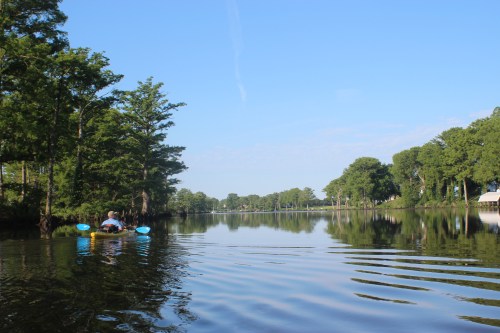
There are some mighty bald cypress trees along the way, as old and stately as any southern Oak I’ve seen. The water is dark and leave stained (tannic) another similarity. The name”Pokomoke” is an American indian name given the river meaning ‘black’ water.
.
In considering the ‘Water Clarity’ of this river, the tip of the paddle remains visible beneath the surface and the clarity is good understanding the tannic qualities, I wouldn’t hesitate to jump in. The clarity changes in the lower river as the tidal flow affects it more.
.
There too are numerous older duck-blinds. In considering the “Natural Quality” of the Pokomoke – we observed deer, wood-ducks, turtles, the signs of beaver, Osprey, eagles, and more along the river. The higher water in the beginning had a few water-snakes on the move; I didn’t bother them.
Its good habitat.
We made Snow Hill, Md an hour and a half after put-in.
The Pokomoke River Canoe Company
.
The water was high enough to paddle right up on their dock; good place for traveller.
.
We weren’t in any hurry, so it was great to stop and check out the character of the little canoe store. ‘Barry’ was present and if you have any questions about the river, paddlin, food, women, hang-nails, or just anything in particular; you’ll feel right at home with his warmth of conversation. We hung around a while then wandered up the street for a cheese-steak.
On return (and with the higher water) Barry had the state ‘bridge-tender’ come down and let us through….. The stop in Snow Hill was a good break
After Snow Hill the stream widens and the wind can be more of a factor.
Below Snow Hill and just off the main river marked by a red/green marker is Shad Landing State Park. In expecting some windy conditions for the day I had noticed in preplanning the river their canoe-trail. Slough-like it winds near the park and around then back into the river a little further downstream – shelter from the wind and a little ‘peace’ for the mind.
Kids were having a ball learning paddling skills near the swimming area.
Shad Landing Canoe trail; a nice little interlude while paddling the river.
When you ‘see’ wood-ducks on a river – that’s a positive indicator for the areas habitat. Wood-ducks know that you are coming long before you can ever catch a glimpse of them – no matter how quiet you are; we were still able to spot a number of sets along the river; beautiful creatures.
Somewhere I read that there were 173 different species of birds/foul along the Pokomoke – I wasn’t counting, but no doubt the river was a special place. We had an Eagle that continuously moved ahead of us much like an Osprey would when taking advantage of prey from the movement of a nearing paddler.
The efforts of many make all of this possible; the duck-house above (one of many) was marked with the boy-scout insignia.
“Rivers are ‘muses’ for your thoughts; barnacles on your brain are those things that you comprehend along the way” tgh
Barnes Landing
Here and there were structures – remnants, farm and otherwise frequently nurtured thoughts of the rivers history as part of the underground railroad during the Civil War
Cracker Jack
“Friendliest town on the eastern shore”
– and they were good to us. We made Pokomoke City after 7.5 hours of paddlin, about 3:30, just in time for the Tiki Hut of the Riverside Grill to open…. Jenny served us with some friendly conversation and a couple frosty beverages, along with a chicken ceasar salad. The city has a wonderful dock running the length of their river frontage, after beverage and conversation two weary paddlers found an opening near the city’s boat ramp and pitched our tents for the night. Soon after, zzzzzzz
It’s been my experience that a good through-paddler goes down with the sun and rises with the morning light.
Being told that the tide could be more of a factor after Pokomoke we paid close attention to the mornings water. High tide, and it was turning around….. you dang right, we were on it!
– after the Nanticoke we figured we had four hours of favorable tide. The wind was an unknown, but you can normally expect calm mornings…..
With the increasing daylight of the summer we were on the water at 630a, in glass-like calm; time to burn…..
Time to enjoy the paddle, and on more than one occasion – wildlife watching us pass (deer in the bushes)
Couldn’t believe the flat-water; after paddling the Nanticoke last fall and being challenged with tide and wind – this was the reward. It was picture perfect paddling. That’s not a dirty spot on your screen, its a crop duster working the crops beyond the horizon.
The extreme tranquility continued as we passed through the area of Rehobeth, onward and around the marsh toward Shelltown, Md
With several grand old fading farms along the water nearing the coastal flats
four hours later, still riding the tide; life among the mud was good
With Shelltown, Md in sight you know that you are nearing the mouth of Pokomoke sound, stay right.
The mornings paddle from Pokomoke had taken 5 hours; Pokomoke Sound and the Chesapeake bay was straight ahead
The Fair island cut was a welcome sight and marks pretty much the end of the Pocomoke river – my curiosity was satisfied in the best of ways.
.
The Pokomoke is not a difficult paddle, 55 miles or so; have a reason. Wildlife is good +. We had favorable conditions, weather was everything. I was packed for three nights out; only used one – a day and a half to paddle. Land-food is available in Snow Hill and Pokomoke…. airplane-mode for the phone.
.
.
We arrived at Pokomoke Sound as the tide stood still before us, nice…..
After stretching on the sandy shore just outside the cut, set our sights 12-miles across the water. On the distant shore is a white windmill, in the direction of that windmill is the structure pictured below. That marks Rumble Point rd. Rumble Point rd was our secondary escape/pickup point from the bay if needed… (Crisfield plan A)
Is was a long paddle in open water. Set a course, adjust with factors, paddle through it. Mental fortitude is a part of any paddling adventure.
.
We made Rumbly Point rd with continued calm waters and investigated the pickup point. I’ve never seen so many mosquito’s on one porch, With favorable conditions we decided to move on…..
Those favorable conditions didn’t last.
It was well after lunch, the heat was rising, and things on the water were starting to roll, twist, stretch, list, and yawl. Time on this water felt like too much like work – not the reason I paddle.
.
With wave-action and conditions worsening; we found a calm canal near Horse Creek and reassessed our objectives. With the phone GPS we located and paddled a ditch onto Phoenix Church rd. very near Crisfield – thats where we called for our ride…..
.

.
We had paddled the Pokomoke river and flirted with the Chesapeake
– it was all good…
.


Leave a comment