Home

Williams Reservoir Co. – Dang, Its Pretty Out There….

Leave a comment

Williams Creek Reservoir, Co.

(2nd try) 8600′ elevation

IMG_5024

.

Water Clarity – 6

Natural Quality – 9+

Difficulty – easy

Second trip to Williams but this time with my “stuff.”

(First Try Here)

June 2015 trip just as nice!

Back down the dusty trail, after forgetting my paddle the day before – it was only right.

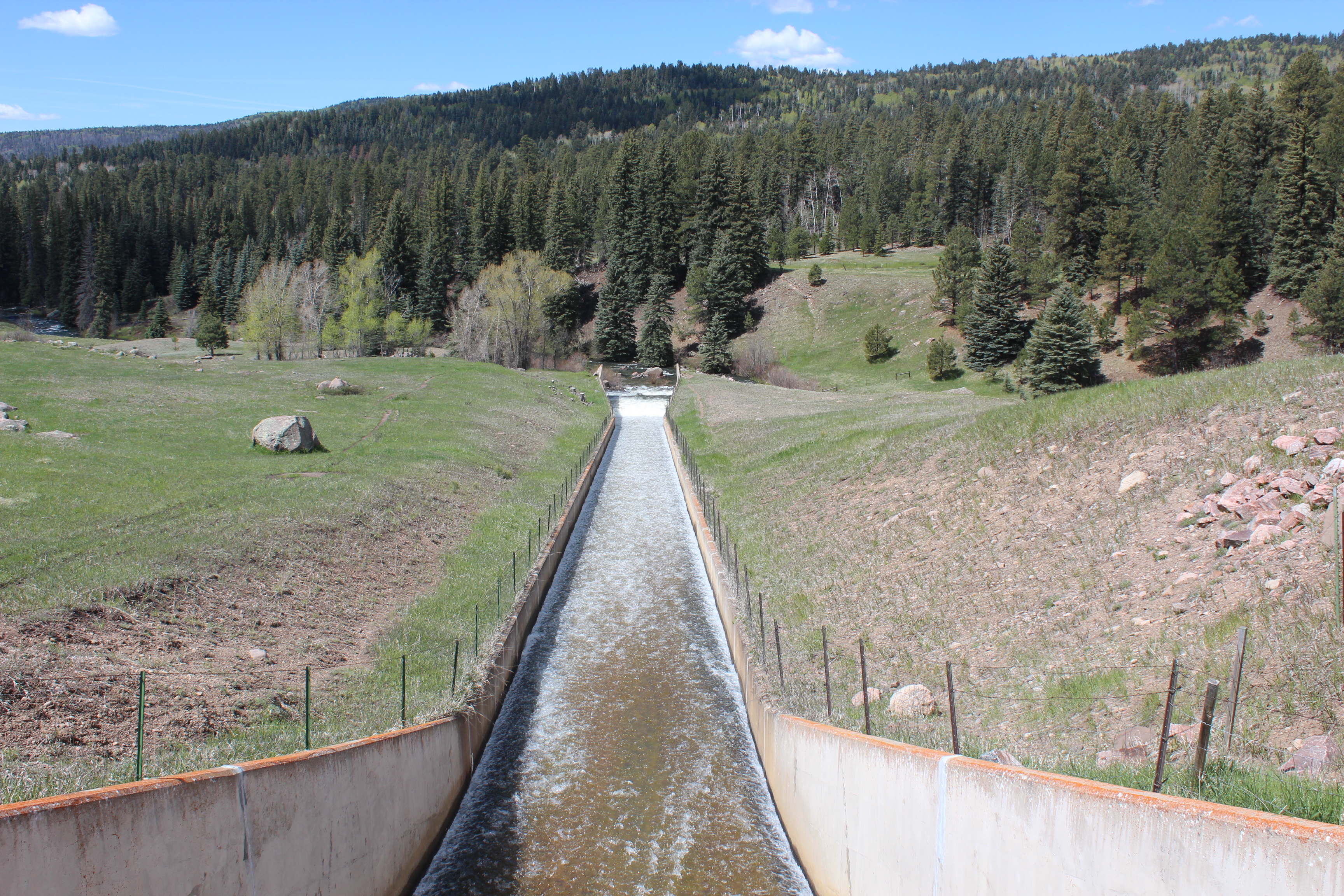
And past The San Piedra trail which runs nearby, so a stop or two to look over the edge along the way,

There is no way to capture the reality of it all with this 2-dollar camera, but it’s a camera that at the moment I don’t mind if sinks or drops – plus, its easier to take a picture than make a note.

Lets see if I can do this any justice…

Put in at the landing where another paddler was already in and some anglers were arriving.

2015

2015

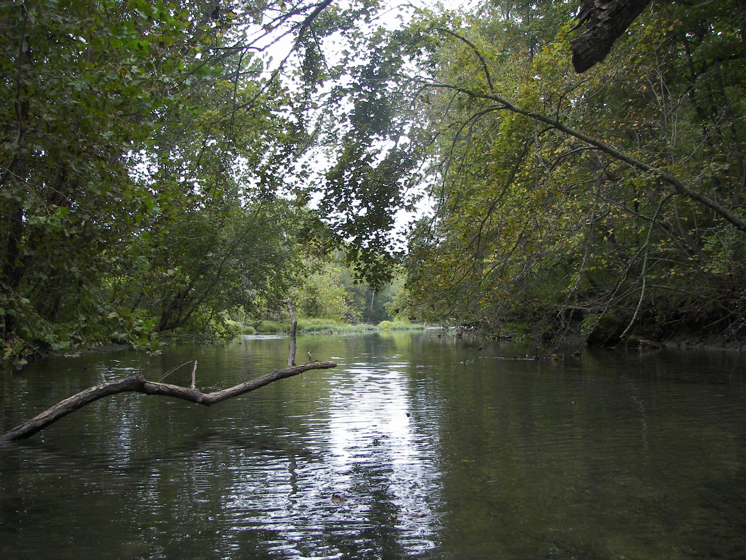
Paddled upstream, there was a calm side to the left.  At the end I pulled the kayak across a short grass field and enjoyed a fine ride back to the lake.

2015

2015

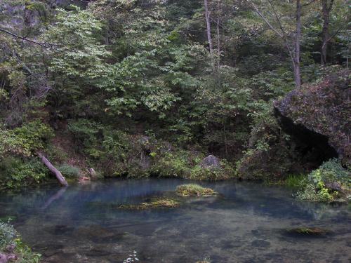
Where the stream enters the lake, there was some serious fishin going on.

The lake itself first struck me as ‘mundane,’ I mean when you can almost see the full circumference of the lake, What is more mundane? The water clarity was clouded with some suspended growth and it seemed shallow, anyway I figured I’d run the shoreline clockwise and get a feel to the ‘lake.’

Talked with Sandra, another paddler in her LL Bean kayak, very similar to my logic – I had noticed and liked the lift rack that she had on her car back at the landing so my first words of course were something like – “hey, I really like your rack!” There was a pause and it seems she was from New Mexico –  a part of paddlin of course is about “gettin away from those “doggone people,” common ground – then after a short drift she went her way and I mine, reminds me that no way would I (personally) consider a ‘two-seater.’

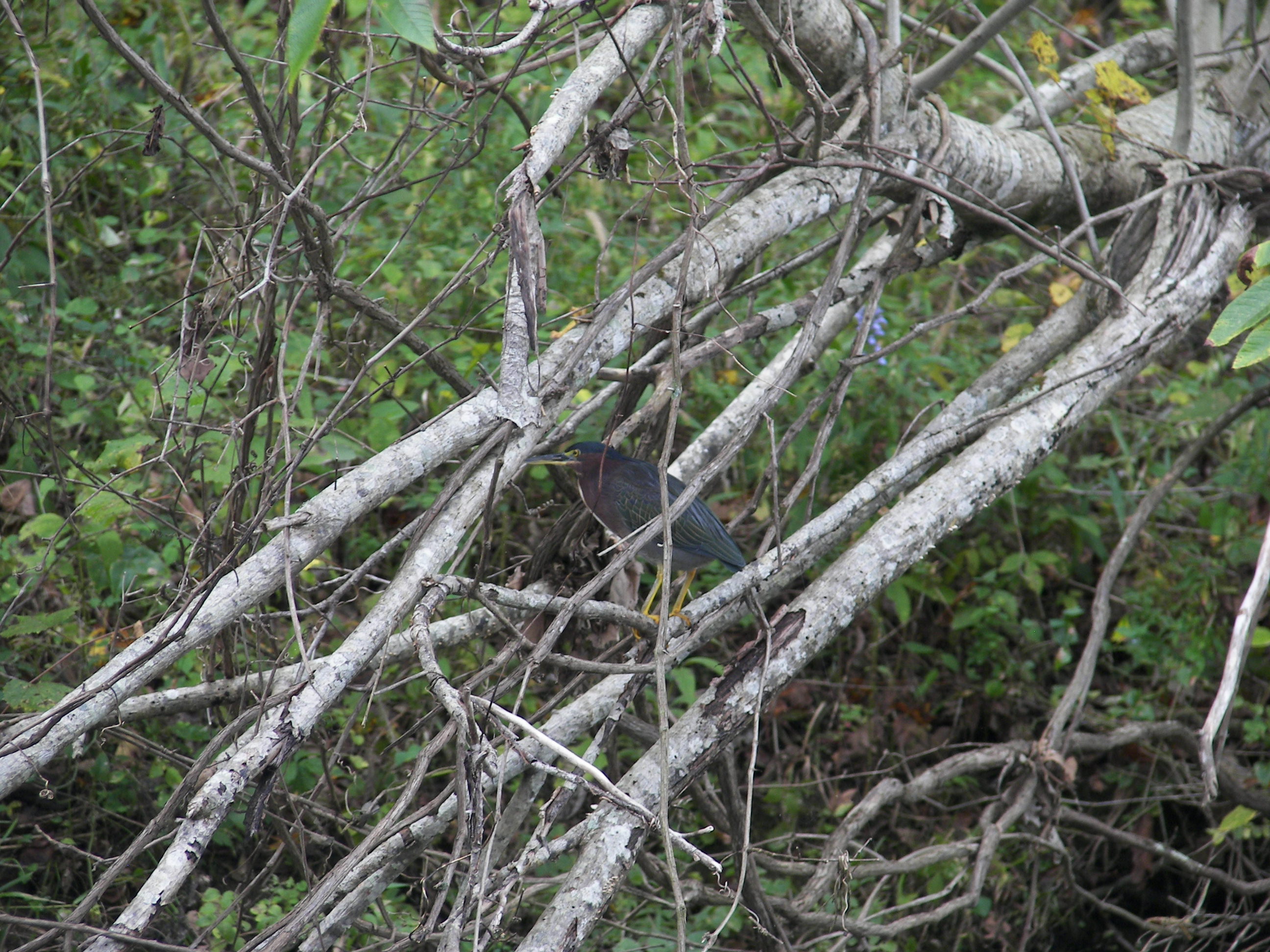
Another couple were fishing about half-way down the lake, we spoke and drifted a bit as he worked on his tackle, I asked a few fishing questions and he educated me a little about of the trout and salmon that are found in this water. Unfortunately, I remember more about the fish than of his name.

1505-IMG_4993

The 2015 water was at 46 degrees, just right for my beverage of leisure (waggitt-adder).

From that point I continued the shoreline up to the spillway, right up to it – edging over…. the water’s volume didn’t seem to pose a problem. The June 2015 trip was after some rain, would have been an easy (and unfortunate) slide down the spillway (well the slide would have been great, the landing might have been regretful)…..

IMG_4971

.

1505-IMG_0586.

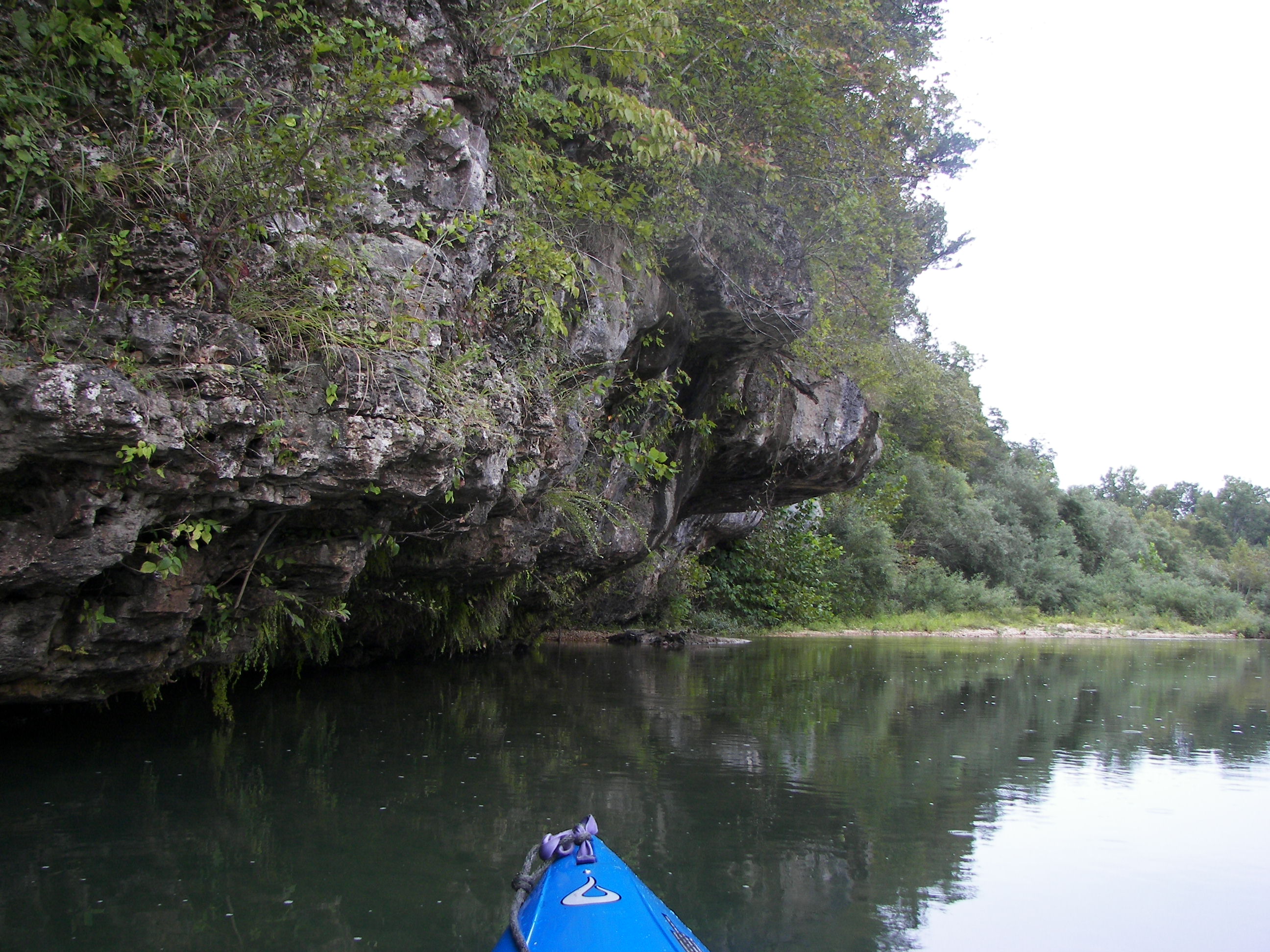
It was after I turned from the spillway that the ‘Natural Quality’ of this lake suddenly stood out before me.  Looking towards Cimarrona Peak, the words that resonated inside these two little portholes of mine were

Dang! it’s pretty out there!

It wasn’t the natural ‘habitat’ so much but simply the overall ‘beauty’ of the surrounding terrain, plus the grand scale of it all.  It was easy to imagine the ancient movement that once etched the valley in the distance, I know there are other places more grand and beautiful, but wow – this is pretty neat and I’m sittin right here ‘in it.’

I continued paddling and drifted the ‘dead-air’ space on the windward side of the lake, then slowly ‘fell in’ with the breeze pushing back down through the middle of the lake.  I guess you can’t always predict staying along one shore especially when coves and inlets are involved – variables include wind, shade, exercise, and what ever your intent was with the trip – this lake had no coves to speak of so ‘dropping-off’ into the breeze on the ‘top side’ and drifting back down the middle was a good option for today.

“Feet-up’ in the dead air space along the shore -‘Oliver’ had his line in the water, but I don’t think it mattered at all whether anything bit.

Again, there’s no way to convey the depth of the valley without seeing it, drifting down the middle of the lake just gave me more time to ponder the magnitude of changes within it all.

Drifted right on by the landing, always the cheap entertainment ‘hot-spot’ of any body of water,

It might seem as though there’s alot of folks around, but that really wasn’t the case at all – everything’s so spread out here – wide open spaces (song), I only came across a few faces.  At a glance Alice resembled my sister Janis (in Afghanistan) so we chatted a bit, being from California she was quick to tell me that I would encounter many ‘doggone people’ while passing through there in the coming weeks.

– then there was the ‘Major the dog backing the Bronco down, not sure if he could fetch a beverage or not.

2015

2015, 2023

IMG_4936

IMG_4942

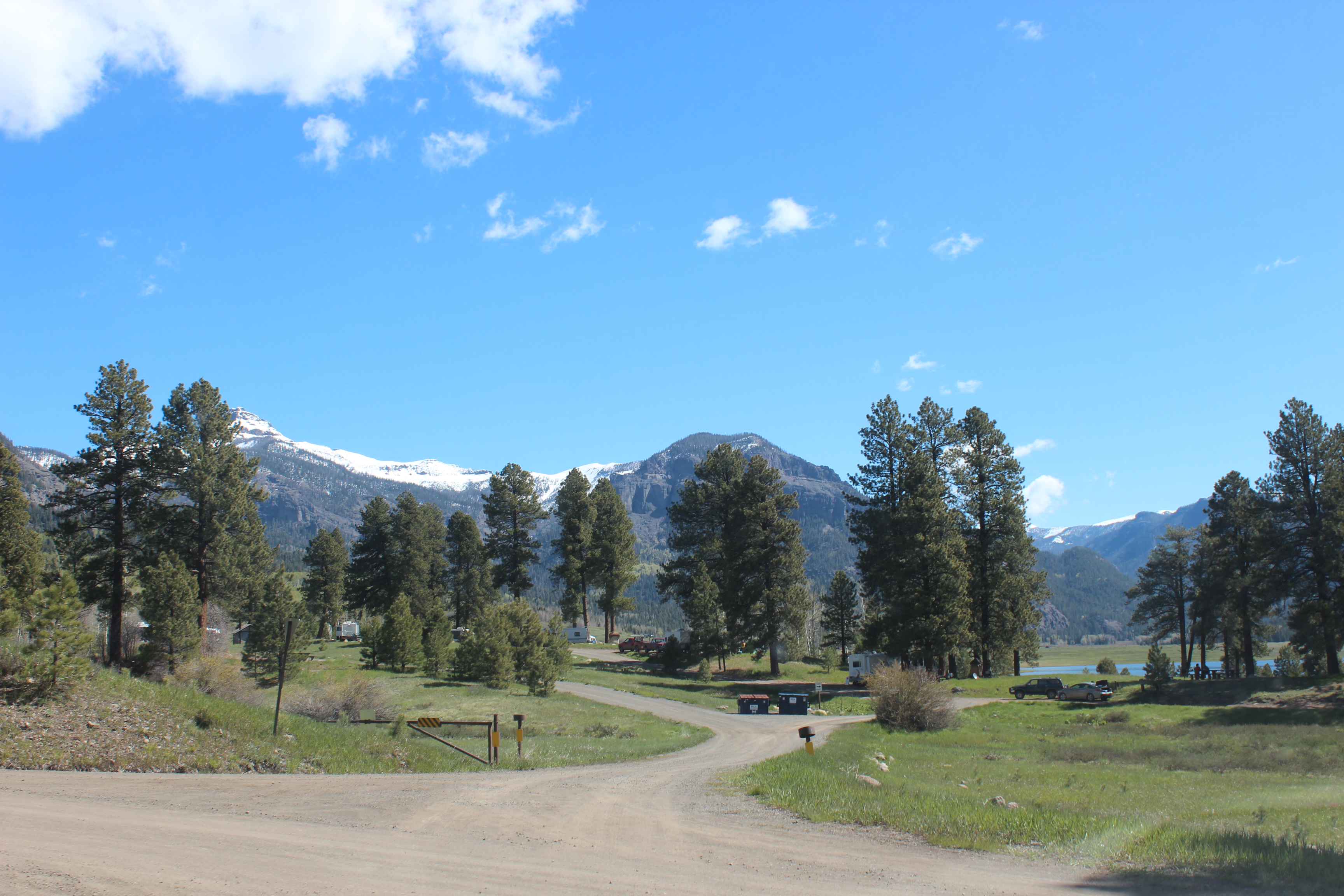
As I left the road passes the campground where just a few of the sites were taken,

and right past this lady Patti, a park volunteer for the past 13 years, she thanked me for not blowing dust all over her with the truck – but I didn’t do it on purpose – no hurry here.  My plans were to drift back down this dirt road just like I had drifted back down the middle of the lake, ez.

The second trip to Williams Lake was worth the dusty drive, I’m sure there are days that the views are even more distinct.  There were paddlers going in as I was headed out – so that told me that it is known and used for a close, easy, and very scenic paddle adventure by locals.  Initially the lake fooled me but somehow became much greater and distinct with the surrounding Scenic Quality, awesome.

1505-IMG_4924

The dusty trail.

.

IMG_4967

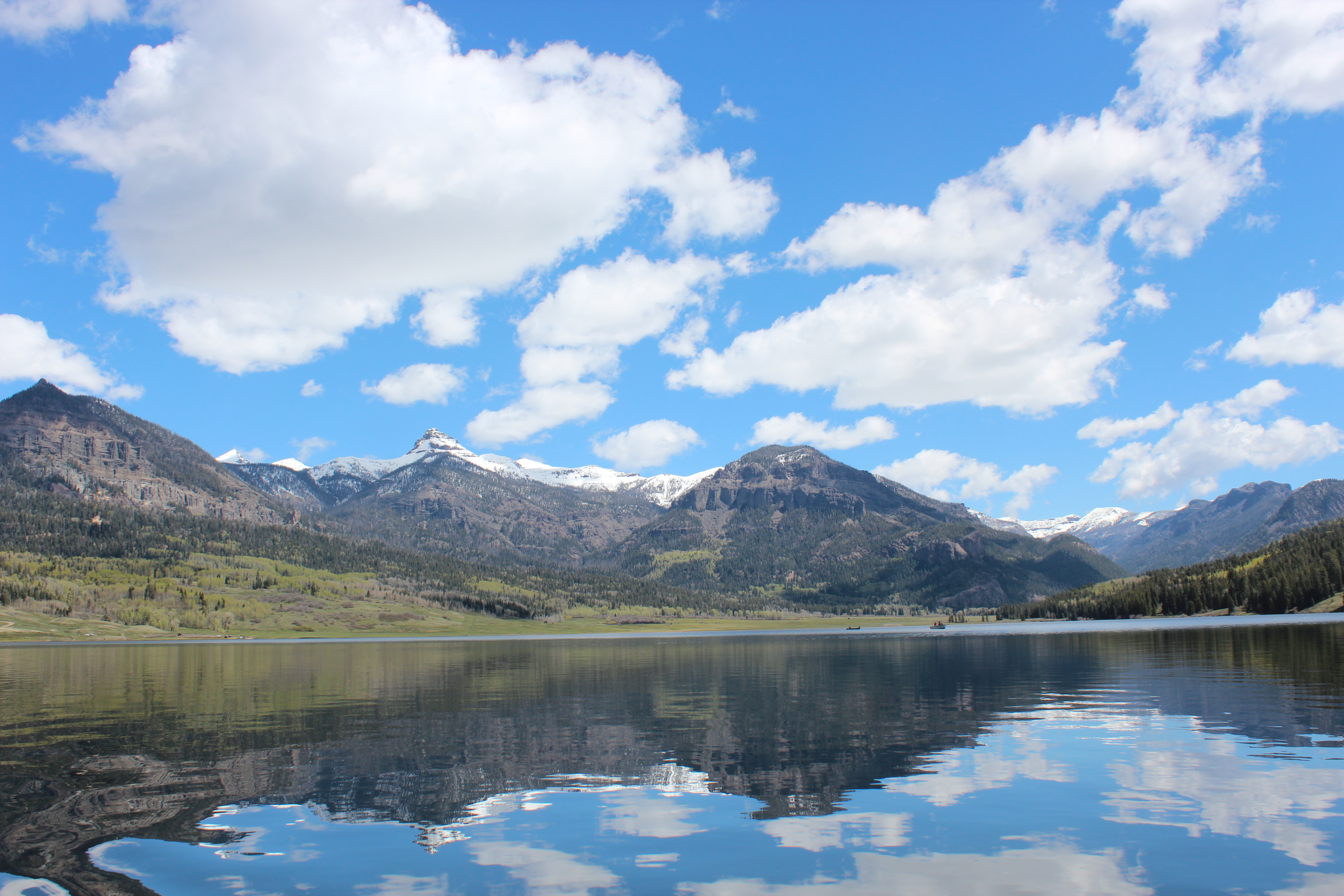
“Dang, it really is pretty out there.”

First Williams Lake Run, Co.

1 Comment

Williams Reservoir, Colorado

So with a little time on my hands I took a ride for a short paddle – Williams creek reservoir in the San Juan National Forest.

Not too difficult a ride,

If a person doesent mind 30 miles of dirt road and a few open range cows….

Found the lake and began to anticipate paddling up stream a little bit, where I noticed a few others paddlin…

I backed up near the ramp and sat comfortably on the opened tailgate of my little truck – it was a good spot to mentally prepare as downed part of my standard Subway sandwich.  After staring into the water and planning a simple route – I eased over and untied my kayak.  When all was said an done, guess what? – NO PADDLE !

HA! – I had forgot my paddle, it was in my little trailer back in Pagosa Springs!…….

so anyway……. I did hang out a little longer, and after laughing within at my own silly situation; back down the dusty trail I went; not a big deal.  Maybe tomorrow I’ll try once again (please see post – I did, Williams Reservoir paddle link here).

Along the way back I also made a stop or two, don’t get too close to the edge.

No I didn’t mind the dirt roads and stuff,

Cause I found a friend along the way to lend an me understanding ear’ (he wasn’t so dumb).

I’ll try again in the next few days, nothing wasted…

(Second trip here)

It just made for some easy time with the GK’s at the small lake behind my daughter’s home….

The Current River

4 Comments

The Current River – Eminence, Mo.

Water Clarity – 9+

Natural Quality – 9

Difficulty – Beginner to Moderate

Perception – Weekday

100_9585

The Current River was the first stop on my ‘leisurely’ drive from the Carolina’s to California; it is located within Missouri’s The Ozark National Scenic Riverway and I would consider it a ‘must-do’ paddle for any serious novice paddler – you will grow from your experience  with this river.

Passing up a planned stop in Kentucky, I arrived at Pulltite Campground a full day ahead of schedule (the lake in Kentucky just didn’t ‘feel right’ plus with a gained hour in time, I drove on)….

It was evening as I passed through the small town of Eminence, Mo – (GPS – 117 Stewart Dr, Eminence, MO) I considered staying at a lower campground – but again moved on to the more remote campground at Pulltite; darkness fell as I parked. Pick your spot.

Pulltite is off the ‘beaten’ path, so much so that I found NO cell service, and of course no internet – so if you have contacts to make; do so before arrival… but hey, thats kinda what paddlin is about (getting away from all that stuff).  On the positive side there is a pay phone (if you remember how to use one) at the site – most of the shuttle folks have ‘800’ numbers – so in the end it all works.

Pulltite Campground

As for me, I did not check in the night before with my shuttle folks and being two days early I went to sleep contemplating my next move – ahead of schedule I could wander the little town the next day and make solid contact and return to paddle the following day – or – leave my vehicle and paddle-on chancing cell-contact down river; or, simply try the pay-phone again in the morning.

Preparations were made and the kayak was loaded in the dark, with @35 miles to the two rivers campsite I was prepared to spend a night on the river, when/if I got on it.

Tossed and turned all night dreaming that I couldn’t fall sleep on the river; go figure.  Arose early and after a shower was surprised to make contact (888#) with Two Rivers(Anita) just after 7 am.  Things fell into place from there and I was able to ‘shove off’ by 730 am.

Sitting comfortably in ‘traveller‘ and headed down river I felt comfort with thoughts of the lakes recently paddled – I appreciated the pleasure of the ‘free-ride‘ that the Current was now providing.

The water clarity of the river surprised me by pushing Silver River’s bar (my personal standard for rating), the setting of the morning was quiet and perfectly peaceful.

Less than a mile downriver was the Old Pulltite Spring, lots of history here and with a short walk down a path there is more to see.

The old cabin was put together using logs in a vertical fashion, nothing much inside except a chimney and lots of graffiti.  Because the logs appear to be creosoted and co-joined, I wouldn’t guess the current construction to be more than 50 years old – just my hunch.

100_9567

Pulltite Spring

– a short walk back to the river.  It was about here too that I was telling myself to slow down on the pictures – everything looked ‘picturesque’ and battery supply was limited.

As I was sizing up the water, the Natural Quality of the area also remained on my mind, soon the wildlife began adding up; turtle, herons, plus an Eagle with its white tail (I had seen 28 on the Mississippi), but there was an Osprey too – one which took my lead all day.  Made me think of an old indian story where an Osprey had led a young boy out of the woods and to safety.

In observation this Osprey had a strategy to stay ahead, it was to grab any morsels that might sense my approaching movement and forget about looking up; a meal.

With the ‘free-ride’ of the Current – I had plenty of time to watch him at work.

100_9598

Martin Bluff on the Current – banjo music?

There were plenty of campsites along the river, places of comfort.  What I really learned on this trip was to come prepared to spend a night on the river, camp – not so much because of the distance in paddling, but as-to actually enjoy the miles more (my return link).

Instead of being in ‘the-cog’ moving down river at the same rate as others – stop, camp early and watch ’em all pass – I think that would honor this river’s atmosphere as it should be appreciated.

On this date the current was not overpowering and was ‘easy to read,’ I could easily understand how so many could just relax and enjoy the ride.

I do not take lots of use from weekend tubers as a negative; as with Juniper Springs,  a positive is that users kept the passage ‘beaten down.’  True that the older trees were a bit scarred (‘beaters’) but in the scheme of things those were simply indicators to watch for the tricky currents.

I was pleased with the lack of trash and unnatural debris on the Current this date, an even larger positive.

Still plenty to ponder as you paddle, or just float by.

or take a walk into…

100_9626

Making it to the Hwy 19 bridge in a little less three hours and thinking it was half-way to Two Rivers – I figured I might just do this paddle in a day; with the overcast I was probably more prepared to sleep than to ‘camp’ (sleeping bag, no tent).

Turns out that from the bridge to Two Rivers was a five hour ‘ride.’  When 4:30 pm came – I really didn’t want it to end.

There were lots of kingfishers, woodpeckers, the Osprey that worked the trees all day ahead of me,  turtles aplenty, the catfish appeared to be camouflaged, an Otter, lots of the smaller mallard-like ducks with white eyes and blue markings (like female wood ducks), egrets, and herons, and the usual crow or two – maybe I should get a ‘bird-book;’ that might work – I’ve always been better with pictures, and they work well as notes too..

Plenty to look at along the river; it just keeps coming and coming –

100_9652

100_9648

Along the way there are many little ‘divits’ (my name) or coves along the river; subtle little areas of natural peace – where the wildlife hangs out and the river’s water stands calm

–  life’s a little slower back there.

100_9663

100_9674

The Current’s alternating depth provides plenty of rapids as well as some placid areas too – its easy to imagine this river and the power of the same clear glacier run-off causing this, plus the native life that this river supported long before we were around…

I made numerous stops to stretch, make a sandwich, and simply ‘calibrate‘ to it all

100_9708

The Current continues to throw the natural quality at you….

I hadn’t seen any more than two folks all day, then I ran into some canoer’s – in talking with them they mentioned this was their 33rd annual trip from Illinois to enjoy the Current river.  I have found others many miles away that have also discovered this river through paddlin it. A canoe would work well on the Current

Around the corner the local outfitters were having their ‘end-of-the-season’ bash (until late into the night) they deserve it for putting up with all the doggone people each year…… that’s probably why I’m paddling too – a break from a lifetime of telling those doggone people that they were always ‘right!’….

100_9766

but all that’s water under the bridge….

The Current River, a free ride.

Well there are still places that Facebook, the internet, and cell service can’t reach – and the Current River between Pulltite and further down than Two Rivers happens to be one of those areas.  It’s a shame that one cant go and enjoy to the fullest without the feeling that contact needs to be made, but I tried – plan to ‘disconnect’ on your visit.

It’s my guess that there are no cell phones nor internet in heaven either – The Current is a little taste of that.

I was told that an overnight was necessary between these points, while I was prepared it didn’t happen, my regret.   It was a leisurely paddle with stops – just kept the kayak in the current (like going down the Mississippi in 32 days) while enjoying the view, feet-up!  I made it from Pulltite to Two Rivers in 9 hours… 730 – 430. 

With this experience; an overnight stay is the only way to fully appreciate this river.

100_9783

The river’s easy to ‘read’ and gentle enough for anyone that you want to put on it, no wonder the canoe/tubing industry is thriving here in the summer – plus its just an awesome place with the cliffs and the region’s wild life.

The river went on and on, didn’t want it to end.

The Current River has plenty of it’s own unique character just waiting for you to enjoy, do so.

.

Akers Ferry to Doniphan on the Current

Lake Adger Option

9 Comments

Lake Adger Option – Up The Green River

Water Clarity – 7 to 8+

Natural Quality – 7 to 8+

Difficulty – Easy to Moderate

Perception – Friday

As I reviewed an earlier Lake Adger post, I felt that it would be only right to enlighten you more of the paddling option from the Marina that was mentioned – so of course it was also a perfect excuse to paddle it once again.

With traveller (kayak) already on the top of the truck I headed back to the Lake Adger Marina – 4585 Lake Adger rd – for those with those Garmin GPS things..

The late fishermen of the morning were putting-in as I was on the water by 930, instead of heading to the Left and the Lake itself my interest today was with the wetlands and the Green River to my right, upstream.

There are several ways to cut through the wetlands in heading up the Green, the main flow and a couple smaller flows.  I took the habitat and enjoyed the peaceful paddling.  After the wetlands its a short paddle before the Silver Creek Bridge comes into view, any current is hardly noticeable – from the bridge it is possible to paddle two hours upstream.

Again, its a very peaceful type of paddle, full of natural beauty and with those thoughts I was feeling a high ‘Natural Quality’ score coming on for this option, kingfisher’s were aplenty.

There were several smaller coves or ‘divit’s‘ to explore, perfect drinking holes for large and small critters – deer tracks were abundant.

Make no mistake if it was a great effort to go upstream I probably wouldn’t do it, but the Silver River and/or The Colorado River (below The Hoover Dam) show that there are times that the paddle is simply worth it…. for the most part you don’t even think about it – your paddle and mind are the only things in motion as the water runs beneath.

More of the same, perfect silence – with the exception of the trickling of several small creeks flowing into the Green – surprising too because for a portion of this paddle upstream there is a highway running to one side.

An hour and a half upstream and the water clarity improves significantly as the waters become more shallow and stream-like.

The Yak is what it is.

With a little more time and distance the sandy sediment turns coarse and rocky, then shallow.  It is possible to follow the channel of the flow and remain paddling – but there are areas too where it is necessary to walk a short distance in the water.

After about two hours and a very short stroll, more to enjoy standing up and having a snack – I feel I’ve done what I’ve set out to do, I’ve enjoyed a wonderful paddle in an awesome setting with very little effort – and in a short period of time.

So I turn with the flow and begin the drift back towards the lake, several miles away.

Unfortunately the recreational activity that occurs up the Green River with the tubers produces an unnatural debris field, the bottom bears the burden of an occasional beverage can, this is where the ‘Natural Quality’ fell – I even found an ipod, a bit waterlogged.

(this is just one of several examples of the tubing activity up the river)

But my concern was not upriver at the moment, its ‘feet-up’ right here – with the lazy drift………

The pictures are all so similar, just more of the same – but in no way is it mundane.  It was a slow ez paddle all the way back to the Silver Creek bridge.

On the lake side of the bridge you can either follow the main volume of flow toward the wetlands, or there is a small flow to the left that goes through the wetlands, I took the small creek of course.

It was mid-day and all the shade just made it better, actually felt ‘cool’ under there.

Out of the wetlands,

– and right back to the Lake Adger Marina, a simple 4 hours.  There’s your Lake Adger option, five or more hours of exploring the lake itself – or a simple paddle up the Green River, then a float back…

It’s there for you, do them both!

‘feet-up’

Older Entries Newer Entries